The low-lying parts of Lincolnshire are covered by an array of maps of intermediate scope, covering a greater area than a single parish but less than the whole county. Typically produced in connection with drainage or water transport, and considerably predating the Ordnance Survey, to which many are comparable, they go back as far as the medieval period, and continue to the late nineteenth century.
This volume covers the Witham Valley, with the East, West and Wildmore Fens north of Boston, but extending as far as Grantham and Skegness, reproducing the most important of the maps and listing the less useful ones.
The history of the drainage of the area is unusually dramatic. By 1750 the Witham was a failed river: the winter floods were worse than they had been for centuries and navigation from Boston to Lincoln had ceased. Over the following sixty years, local interests, aided by some able engineers, brought both navigation and drainage to a state of perfection that made Lincolnshire prosperous and fed the industrial north.
These maps, reproduced here to a very high quality and in both colour and black and white, are an essential tool for understanding this history, and the volume thus illuminates certain episodes that have previously been opaque. They are accompanied by a cartobibliography and introduction.
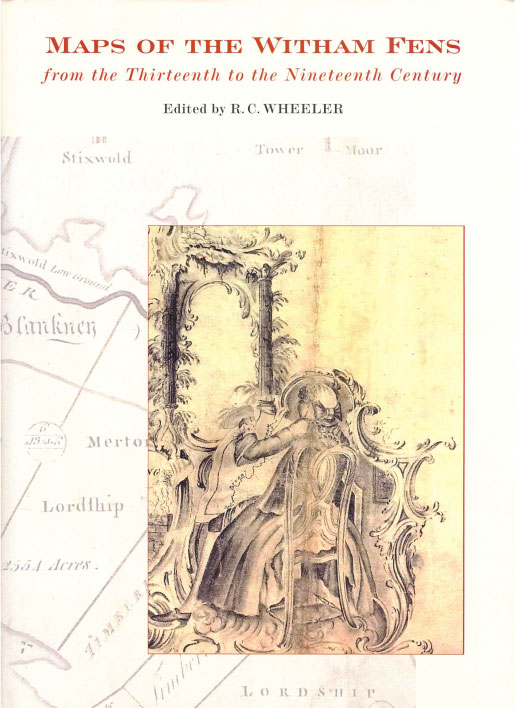
Jacket Illustration The jacket illustration is taken from the manuscript version of John Grundy’s 1762 plan setting out his proposed improvements to the Witham, It appears to show Grundy himself, engaged in drawing a plan of the Witham.
Volume 96 Maps of the Witham Fens from the Thirteenth to the Nineteenth Century
Editor R.C. Wheeler
Dust Jacket Biography Dr Robert Wheeler is Honorary Secretary of the Charles Close Society for the study of Ordnance Survey maps.
Publication Date 2008
Size 325 x 230mm
Language English
Publisher A Lincoln Record Society publication published by the Boydell Press an imprint of Boydell & Brewer Ltd PO Box 9, Woodbridge, Suffolk, IP12 3DF and of Boydell & Brewer Inc. 668 Mt Hope Avenue, Rochester, NY 14620, USA
Website: www.boydellandbrewer.com
Designer Designed and typeset in Bulmer by The Stingray Office, Manchester
Printer Not stated
Printed on acid-free paper
ISBN 978-0-90150-383-1
Content Contents, 1 page
Acknowledgements, 1 page
Abbreviations, 1 page
Introduction, 21 pages
Cartobibliography, 44 pages
Reproduction of Maps, 100 pages
Select bibliography, 1 page
Index of Persons, 1 page
Index of Places, 4 pages
Dust jacket blurb The low-lying parts of Lincolnshire are covered by an array of maps of intermediate scope, covering a greater area than a single parish but less than the whole county. Typically produced in connection with drainage or water transport, and considerably predating the Ordnance Survey, to which many are comparable, they go back as far as the medieval period, and continue to the late nineteenth century.
This volume covers the Witham Valley, with the East, West and Wildmore Fens north of Boston, but extending as far as Grantham and Skegness, reproducing the most important of the maps and listing the less useful ones.
The history of the drainage of the area is unusually dramatic. By 1750 the Witham was a failed river: the winter floods were worse than they had been for centuries and navigation from Boston to Lincoln had ceased. Over the following sixty years, local interests, aided by some able engineers, brought both navigation and drainage to a state of perfection that made Lincolnshire prosperous and fed the industrial north.
These maps, reproduced here to a very high quality and in both colour and black and white, are an essential tool for understanding this history, and the volume thus illuminates certain episodes that have previously been opaque. They are accompanied by a cartobibliography and introduction.
Review ….this publication is a tour de force in map reproduction publishing. SHEET LINES Journal of the Charles Close Society.